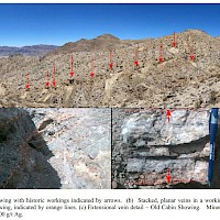
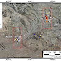
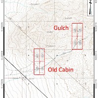
The Silver Mountain Property is centred at 37° 13’N 117° 28’ W, approximately 57 km southwest of Goldfield in Esmeralda County. The property can be reached by road with a 4x4 vehicle. The property consists of 8 claims, staked in two blocks and located in Sections 26, 27 & 34, Township 8S, Range 40E. The claims are on BLM land with no surface impairments.
While there are numerous exploration workings dating back to at least 1917 in the Silver Mountain Property area, there is little documentation of past exploration or mineralization in the public record. The claims cover six Mineral Resources Data System (MRDS) showings. Most of the mineralization is at the Old Cabin (South Silver Mountain) and Gulch (North Silver Mountain) showings, where evidence of limited high-grade mining is evident. Nevada Bureau of Mines & Geology records document two samples in the area running 1500 and 3000 ppm Ag respectively with one sample returning 3.5 ppm Au. Silver Range examined, sampled and staked the property in March and June 2021.
The Silver Mountain Property is underlain by Sylvania Pluton granodiorite cut by inferred mesothermal or deep epithermal oxidized quartz veins. At the Gulch Showing, the veins form a single, steeply-dipping, north-striking system traced for about 400 m in workings. Grab samples from this zone have returned up to 3,270 g/t Ag. A chip of 0.6 m @ 1,415 g/t Ag and 0.48% Cu was sampled across the face of a drift in the Silver Bowl Mine, the most significant workings along the principal Gulch structure. On surface, chip sampling returned up to 0.4 m @ 1,245 g/t Ag from a vein exposed in a pit near the southern end of the principal structure. At the Old Cabin Showing, numerous, moderately west-dipping, planar extensional veins are exposed in workings along a small ridge. They cut the intrusive rocks over a vertical distance of more than 30 m, forming a stacked vein array. Grab samples from this zone have returned up to 394 g/t Ag.
This property was optioned to Walker Lane Resources Ltd. in March 2025.


