- Under option to Broden Mining (see news releases dated September 1, 2016 and August 31, 2021)
Broden Mining Ltd. agreement on Silver Range Project
Under the terms of a 2016 letter of intent and as most recently amended on August 31, 2023, Broden Mining Ltd., a private British Columbia company, holds an option to acquire a 100% interest in the Silver Range project by making a series of timed share issuances to Silver Range as specific milestone events are achieved over a period ending August 31, 2024. Silver Range will also retain net smelter return royalty interests of 2% on all future precious metals production and 1% on all future non-precious metals production from the Silver Range project. In addition to the timed share issuances outlined above, the transaction is conditional upon Broden successfully completing agreements with various third parties on or before August 31, 2024.
Silver Range Project
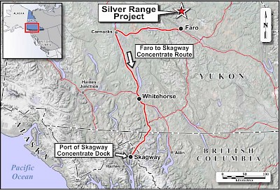
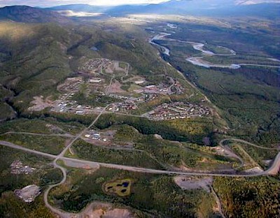
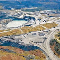
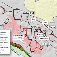
The Silver Range project is located in an area of exceptional infrastructure near the town of Faro, Yukon. During the 1970s and 1980s, Faro was the site of the largest open-pit lead-zinc-silver mining operation in Canada, and at times the third largest zinc producer in the world. In 2010, Strategic Metals began to investigate the Faro area, not for SEDEX-style lead-zinc deposits that the district is known for, but for silver-rich mineralization in a geological setting with strong parallels to the Bolivian tin belt - a premier address for global silver deposits.
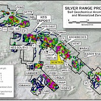
Since 2011, 38.7 million ounces of silver have been outlined at the Keg Deposit (see inferred resource table below). Twenty five additional silver-bearing zones and thirteen discrete soil geochemical anomalies have been identified to date throughout the project, which now covers over 1,000 sq km. Collectively, these define two major mineralized belts: the 17 km Mount Mye Trend and the 70 km Tay Trend.
Keg Deposit:
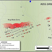
Systematic grid drilling in 2011 and 2012 successfully outlined bulk tonnage silver-polymetallic mineralization at the Keg Main Zone along a 1,100 m strike length and to depths up to 375 m. In November 2012, an initial resource estimate and excellent metallurgical results were announced for the Keg Deposit.
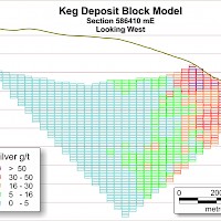
At a cut-off grade of 16 g/t silver, the Keg Deposit hosts an inferred resource of 39.8 million tonnes grading 30.3 g/t silver with contained metal estimates of 38.7 million ounces of silver, 675 million pounds of zinc, 228 million pounds of lead, and 131 million pounds of copper:
| Cut-off (Silver g/t) |
Tonnes | Inferred Resource Grades | Silver Ounces | |||||
|---|---|---|---|---|---|---|---|---|
| Silver (g/t) |
Lead (%) | Zinc (%) | Copper (%) | Tin (ppm) |
Indium (ppm) | |||
| 10 | 63,970,000 | 23.63 | 0.21 | 0.64 | 0.12 | 224.5 | 5.07 | 48,599,419 |
| 12 | 54,640,000 | 25.80 | 0.22 | 0.68 | 0.13 | 238.5 | 5.29 | 45,323,287 |
| 14 | 46,730,000 | 27.97 | 0.24 | 0.72 | 0.14 | 252.0 | 5.50 | 42,022,245 |
| 16 | 39,760,000 | 30.25 | 0.26 | 0.77 | 0.15 | 265.7 | 5.77 | 38,668,984 |
| 18 | 33,900,000 | 32.55 | 0.27 | 0.81 | 0.16 | 278.8 | 6.02 | 35,476,576 |
| 20 | 29,210,000 | 34.74 | 0.29 | 0.85 | 0.16 | 292.5 | 6.24 | 32,625,139 |
| 22 | 25,390,000 | 36.79 | 0.31 | 0.89 | 0.17 | 303.4 | 6.44 | 30,031,947 |
| 24 | 21,990,000 | 38.94 | 0.32 | 0.92 | 0.18 | 315.7 | 6.63 | 27,530,378 |
| 26 | 18,970,000 | 41.16 | 0.34 | 0.96 | 0.19 | 328.8 | 6.85 | 25,103,467 |
| 28 | 16,470,000 | 43.31 | 0.36 | 0.99 | 0.19 | 341.8 | 7.10 | 22,933,629 |
| 30 | 14,340,000 | 45.44 | 0.37 | 1.02 | 0.20 | 355.3 | 7.24 | 20,949,732 |
| 32 | 12,520,000 | 47.54 | 0.39 | 1.05 | 0.20 | 366.9 | 7.33 | 19,136,147 |
| 34 | 10,940,000 | 49.65 | 0.41 | 1.07 | 0.21 | 379.9 | 7.41 | 17,463,351 |
| 36 | 9,570,000 | 51.75 | 0.44 | 1.09 | 0.21 | 390.1 | 7.41 | 15,922,575 |
| 38 | 8,430,000 | 53.75 | 0.46 | 1.11 | 0.21 | 399.8 | 7.48 | 14,567,903 |
| 40 | 7,480,000 | 55.63 | 0.48 | 1.12 | 0.21 | 409.4 | 7.47 | 13,378,323 |
For further details please see the technical report entitled “Geology, Mineralization, Geochemical Surveys, Diamond Drilling, Metallurgical Testing and Mineral Resources at the Keg Property” dated December 19, 2012 and amended May 27, 2013 and filed on SEDAR.
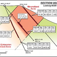
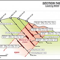
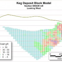
Metallurgical results show that the Keg Deposit mineralization responds very well to conventional copper/lead/zinc flotation processing with excellent recoveries of payable metals. Cross-sectional views indicate a favourable orientation of the mineralized zone relative to topography. The mineralization remains open along strike to the west and downdip. Highlight drill holes at the Keg Zone include:
| Hole No. | From (m) | To (m) | Interval (m) | Ag (g/t) | Pb (%) | Zn (%) | Cu (%) | Sn (ppm) | In (ppm) |
|---|---|---|---|---|---|---|---|---|---|
| KEG-10-01 | 59.30 | 185.00 | 125.70 | 50.09 | 0.65 | 1.20 | 0.14 | 217.00 | 9.55 |
| KEG-10-04 | 24.34 | 64.46 | 40.12 | 49.63 | 0.74 | 1.71 | 0.17 | 180.00 | 14.70 |
| KEG-11-05 | 135.13 | 172.82 | 37.69 | 49.62 | 0.45 | 1.25 | 0.08 | 569.00 | 4.16 |
| KEG-11-07 | 213.35 | 253.10 | 39.75 | 71.74 | 0.60 | 2.03 | 0.24 | 391.00 | 14.39 |
| KEG-11-09 | 25.45 | 130.15 | 104.70 | 70.55 | 0.54 | 0.60 | 0.17 | 778.00 | 1.77 |
| including | 78.33 | 108.81 | 30.48 | 119.90 | 0.72 | 1.14 | 0.32 | 1,168.00 | 3.38 |
| KEG-11-12 | 77.12 | 96.00 | 18.88 | 60.78 | 0.67 | 1.59 | 0.21 | 275.00 | 13.78 |
| KEG-11-15 | 6.10 | 47.85 | 41.75 | 46.62 | 0.47 | 0.27 | 0.06 | 138.00 | 0.91 |
| KEG-11-16 | 212.72 | 247.00 | 34.28 | 46.66 | 0.24 | 1.91 | 0.33 | 280.00 | 23.58 |
| KEG-11-17 | 156.06 | 220.37 | 64.31 | 40.55 | 0.39 | 1.02 | 0.10 | 235.00 | 6.49 |
| and | 258.17 | 297.79 | 39.62 | 41.81 | 0.25 | 1.15 | 0.41 | 383.00 | 12.30 |
| KEG-11-18 | 65.60 | 120.69 | 55.09 | 58.46 | 0.70 | 1.92 | 0.17 | 205.00 | 16.37 |
| KEG-11-22 | 122.02 | 197.20 | 75.18 | 57.46 | 0.31 | 2.41 | 0.64 | 912.00 | 17.66 |
| KEG-11-23 | 236.83 | 271.61 | 34.78 | 40.09 | 0.21 | 1.67 | 0.55 | 398.00 | 14.42 |
| KEG-12-47 | 6.64 | 75.39 | 68.75 | 63.45 | 0.48 | 0.43 | 0.09 | 448.00 | 0.96 |
| including | 11.00 | 39.70 | 28.70 | 131.59 | 0.95 | 0.77 | 0.15 | 651.00 | 1.70 |
| KEG-12-48 | 277.16 | 318.35 | 41.19 | 48.81 | 1.04 | 1.16 | 0.12 | 317.00 | 4.70 |
| Including | 277.16 | 302.08 | 24.92 | 76.98 | 1.68 | 1.87 | 0.19 | 480.00 | 7.59 |
| KEG-12-56 | 5.00 | 47.00 | 42.00 | 45.65 | 0.60 | 0.39 | 0.11 | 569.00 | 1.09 |
| KEG-12-66 | 80.00 | 128.00 | 48.00 | 36.64 | 0.22 | 0.66 | 0.10 | 261.00 | 2.25 |
| including | 98.00 | 128.00 | 30.00 | 51.86 | 0.29 | 0.99 | 0.15 | 288.00 | 3.46 |
| including | 104.00 | 118.30 | 14.30 | 92.41 | 0.49 | 1.75 | 0.30 | 440.00 | 6.13 |
The potential for additional resources, access to existing infrastructure and favourable geometries within the Keg Deposit, are all favorable for the project’s economics.
Hammer Zone:
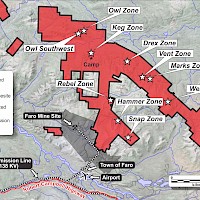
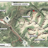
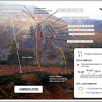
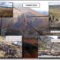
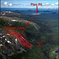
The Hammer Zone is a bonanza-grade silver-rich epithermal vein system that was discovered in late 2011. It is located only 12 km from the Faro mine and mill site. High-grade rock samples assaying from 1,420 to 16,985 g/t silver were collected over a 350 m strike length and are associated with a 700 m long by 100 to 200 m wide soil geochemical anomaly. This anomaly is characterized by very high silver (5 to 68.6 g/t) and antimony (2.64 to 27.2 ppm) values and extends under glacial cover at both ends.
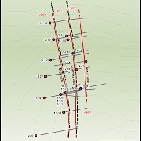
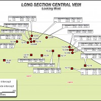
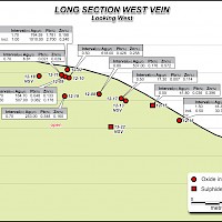
A total of 20 holes (4,197 m) have been completed at the Hammer Zone since 2012. Broadly-spaced drilling traced three subparallel veins for strike lengths of up to 600 m and through a vertical range of 280 m. Fifteen of the 20 drill holes intercepted one or more veins in a grade range between 237 and 4,620 g/t silver. The weighted average of 16 individual vein intercepts is 807 g/t silver over an average drill intersected width of 0.66 metres. All veins are open for extension along strike and to depth. Highlight drill holes at the Hammer Zone include:
| Hole No. | From (m) | To (m) | Interval (m) | Ag (g/t) | Pb (%) | Zn (%) | Vein | Mineralization Type |
|---|---|---|---|---|---|---|---|---|
| HAM-12-002 | 22.70 | 24.40 | 1.70 | 764.59 | 1.78 | 0.20 | West | Oxide |
| including | 22.70 | 23.70 | 1.00 | 1,010.00 | 2.70 | 0.24 | West | Oxide |
| HAM-12-003 | 47.30 | 48.50 | 1.20 | 328.00 | 0.19 | 0.12 | East | Oxide |
| HAM-12-005 | 38.10 | 38.60 | 0.50 | 980.00 | 0.23 | 0.63 | Central A | Oxide |
| HAM-12-005 | 66.60 | 68.00 | 1.40 | 472.12 | 0.22 | 0.67 | Central B | Oxide |
| including | 67.50 | 68.00 | 0.50 | 1,290.00 | 0.58 | 1.71 | Central B | Oxide |
| HAM-12-006 | 50.70 | 51.20 | 0.50 | 578.00 | 1.40 | 0.59 | Central A | Oxide |
| HAM-12-008 | 107.00 | 107.80 | 0.80 | 537.00 | 0.18 | 0.57 | West | Oxide/Sulphide |
| HAM-12-009 | 56.30 | 58.00 | 1.70 | 164.70 | 0.05 | 0.13 | West | Oxide |
| including | 56.30 | 56.80 | 0.50 | 507.00 | 0.08 | 0.18 | West | Oxide |
| HAM-12-010 | 62.10 | 62.60 | 0.50 | 618.00 | 0.43 | 0.26 | West | Oxide |
| and | 118.40 | 121.90 | 3.50 | 125.06 | 0.09 | 0.11 | Central A | Oxide |
| including | 119.90 | 121.90 | 2.00 | 195.80 | 0.13 | 0.12 | Central A | Oxide |
| and | 131.20 | 131.70 | 0.50 | 559.00 | 1.36 | 0.93 | Central B | Oxide |
| HAM-12-011 | 128.70 | 130.00 | 1.30 | 1,052.77 | 0.64 | 0.43 | Central | Oxide |
| including | 128.70 | 129.40 | 0.70 | 1,590.00 | 1.13 | 0.47 | Central | Oxide |
| HAM-12-016 | 262.35 | 264.00 | 1.65 | 140.20 | 2.07 | 3.43 | Central | Sulphide |
| including | 263.24 | 264.00 | 0.89 | 258.00 | 3.80 | 6.30 | Central | Sulphide |
| HAM-12-017 | 185.15 | 186.78 | 1.63 | 1,509.53 | 2.93 | 1.66 | Central | Sulphide |
| including | 186.25 | 186.78 | 0.53 | 4,620.00 | 8.99 | 4.84 | Central | Sulphide |
Silver Range Resources considers the Hammer Zone to be very significant because of the exceptional grades and proximity to infrastructure. It is an excellent complement to the bulk tonnage polymetallic mineralization at the Keg Zone.
High-grade silver mineralization was discovered in 2012 at the Cody Zone, 500 m southeast of the Hammer Zone. Eleven rock samples taken from an 800 by 500 m area of talus assayed greater than 1,000 g/t silver, with a peak value of 16,069 g/t silver. The Cody Zone has not yet been drilled and is a priority exploration target for 2013. The Cody Zone appears to be an epithermal vein system similar in tenor to the Hammer Zone.
Owl Southwest:
The Owl Southwest Zone is a new high-grade discovery located 7.3 km northwest of the bulk-tonnage Keg Zone. Two scout drill holes totalling 500 m were completed in 2012. Both drill holes returned significant silver values, including 5,370 g/t silver over 0.34 m in hole OSW-12-1 and 432 g/t silver over 1.50 m in hole OSW-12-2 (see figure below). Drilling targeted vein mineralization exposed in a surface trench, a chip sample from which assayed 4,770 g/t silver. Eight surface rock samples from the Owl Southwest area assayed greater than 1,000 g/t silver, to a maximum of 6,920 g/t silver. The discovery occurs near the edge of an extensive upland marsh marked by a strong open-ended 200 by 350 m silver in soil geochemical anomaly (10 to 208 g/t silver). The 2013 drill program successfully extended the known mineralized zone along strike to the northeast and down-dip. Hole OSW-13-005 intersected 2.61 m grading 152.4 g/t silver while hole OSW-006 returned 11.18 m grading 42.58 g/t silver. These 2013 holes are located 50 m along strike and 50 m down dip, respectively, from the high-grade intercept in OSW-12-001.
Snap Zone:
The Snap Zone lies 6 km southeast of the Hammer Zone within the Mount Mye Trend. It is associated with an exceptional soil geochemical anomaly, where strongly to very strongly anomalous silver (2-75.8 g/t), lead (200-7,360 ppm) and tin (20-302 ppm) values occur over an area measuring 3,700 by 2,250 m. The first phase of reconnaissance drilling has tested approximately 3% of the geochemically anomalous area to relatively shallow depths.
Seven drill holes (1,767 m) were completed in the Snap Zone in 2012. These holes were located north of drill hole SNP-11-02, which intercepted 480 g/t silver over 2.27 m within a 50.86 m interval that averaged 33.3 g/t silver. Drilling in 2012 intercepted broad intervals of silver-lead-zinc-tin-indium mineralization associated with a wide, northerly-trending structural zone. Encouraging results include 27.65 g/t silver, 1.458% zinc, 0.745% lead together with significant tin and indium values over 29.85 m in hole SNP-12-006. Mineralogical and texture features are consistent with the upper portions of an epithermal system. The structural zone has been traced for 400 m along strike and remains open in all directions. The Snap target area has significant exploration potential for both bonanza-grade silver and bulk-tonnage mineralization similar in tenor to the Keg Deposit.
Risby Zone:
The Risby Zone is located 9 km to the southeast of the Hammer Zone. A single hole (RBY-12-001) completed in 2012) returned 58.38 g/t silver over 9.60 m. There is little bedrock exposure in the area; therefore, the extent and and orientation of the mineralization is uncertain. This was the first hole ever drilled at the Risby Zone and the drill results are considered to be very encouraging.
Vent Zone:
The Vent Zone was discovered in 2012 and is located 20 km east-southeast of the Keg Main Zone. It is associated with a very strong 600 by 400 m silver-arsenic-lead soil anomaly. Ten samples of mineralized quartz veins and altered pyroclastic rocks collected throughout the Vent soil anomaly returned more than 150 g/t silver, with a peak value of 673 g/t silver. Limited excavator trenching returned 247.08 g/t silver and 1.304% lead across an 8 m interval that remains open to extension on one side. Other trench results indicate potential for bulk tonnage mineralization, with values including 21.02 g/t silver over 21 m.
Rebel Zone:
At the Rebel Zone, drill hole Reb-11-2 intersected 155.84 g/t silver, 12.43% lead and 3.07% zinc over a 6.16 m interval. This hole cut fracture-related galena and sphalerite mineralization in partially oxidized volcaniclastic rocks. The 2011 Rebel drilling is located near the north margin of a broad (1,750 m by 1,100 m) area of strongly anomalous silver, zinc, lead, copper and tin soil geochemistry. Historical drilling in the Rebel area returned 2.28% zinc, 0.10% lead and 0.10% copper over 61 m, with no assays reported for silver and other elements. Several other previous Rebel holes cut fracture-related mineralization, but little systematic core sampling was done. Silver Range completed a reverse circulation drill program at the Rebel Zone in 2012.
Owl Zone:
At the Owl Zone, drill hole Owl-11-3 intercepted a broader mineralized zone assaying 11.77 g/t silver together with lead-zinc values over a 28.13 m interval. This hole is situated 150 m to the south of the strongest soil geochemical anomalies in the Owl Zone (with values of 5.0 to 87.7 g/t silver).
Other Mineralized Zones Not Yet Drilled:
The RGS Zone is situated 8 km to the southeast of the Keg Main Zone. A government stream sediment sample from this area returned high lead and tin values, which are 99 percentile anomalies for the entire Selwyn Basin. A multi-element soil anomaly spans a 1000 by 1000 m area and remains open to the west. This anomaly contains strongly elevated silver values from 10 to a 226 ppm (or 6.59 ounces per ton), representing the highest silver-in-soil value collected to date on the property. The anomalous soil values are accompanied by a zone of silica alteration that has been identified over an area measuring 2 km long by 100 to 500 m wide. Thirteen rock samples collected from this zone averaged 123 g/t silver, with accompanying high tin values to a peak of 15,400 ppm (1.54%).
The Zeno Zone lies 13 km to the west northwest of the Keg Main Zone. A one square kilometer multi-element soil anomaly is defined by moderately to strongly anomalous silver (from 5 to 11.15 ppm), lead (from 500 to 1005 ppm) and tin (from 10 to 59.3 ppm) and is open to the west. The metal rich soil overlies hornfelsed sedimentary rocks adjacent to a small intrusive body. Six rock samples collected from this zone averaged 53 g/t silver and 1.23% zinc.
The Archimedes Zone is situated 16 km east of the Keg Main Zone, along trend between the Drex Zone and the Marks Zone. It lies about 1000 m upstream of a prominent gossan and is marked by a multi-element soil geochemical anomaly that measures approximately 300 by 400 m. Five rock samples from this zone averaged 238.8 g/t silver and 3.75% lead.
The Euclid Zone is located 17 km southeast of the Keg Main Zone. A 300 by 600 m soil geochemical anomaly contains silver values from 2 to 12.95 ppm. Five rock samples of altered shale collected near a granitic dyke returned elevated silver (from 4.65 to 23.6 ppm).
The Newton Zone, discovered in 2013, is located 17 km southeast of the Keg Main Zone, silver-lead-zinc mineralization was identified in outcrop. A sample collected from a 5 m wide fault exposed in bedrock along an east trending linear feature yielded 30.44% zinc with 29.5 g/t silver. A near-source float sample collected 800 m to the east along the same linear feature produced 982 g/t silver with 4.180% lead and 9.730% zinc.
The Gauss Zone, also discovered in 2013 is located 45 km southeast of the Keg Main Zone, two silver-copper-lead showings were identified along a linear depression on a northwest trending ridge. Two separate bedrock samples, located 1,700 m apart along the linear depression, yielded 504 g/t silver, 1.060% copper and 14.350% lead; and 44.1 g/t silver, 2.280% copper and 2.860% lead. Both samples are associated with steeply dipping, northeast trending fracture sets.
The Ku Zone is situated 43 km to the southeast of the Keg Main Zone and was staked during the 2011 season to cover an area where regional government stream sediments returned strongly anomalous gold (2.44 g/t) together with high arsenic, antimony and silver values. A reconnaissance soil sample collected in this area yielded 23.9 ppm silver, while five rock samples returned an average of 85.29 g/t silver and 0.163 g/t gold.
The Snail Zone lies 30 km to the northwest of the Keg Main Zone. Reconnaissance sampling returned a very high gold value of 11.6 g/t from soil associated with a clay-altered shear.
The Keg South Zone is located 3 km to the south of the Keg Main Zone. It was discovered by following up a cluster of high copper values that were not supported by other metals. Surprisingly, three relatively uninteresting rocks picked up within the anomalous area returned 7.58 to 43.5 ppm silver with 0.045 to 0.105% copper.
District-Scale Trends
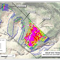
Collectively, 26 silver-bearing mineralized zones and numerous other soil geochemical anomalies now identified on the Silver Range property define two major district-scale trends: the 70 km long Tay Trend, which includes the bulk tonnage Keg Zone Deposit, and the 17 km long Mount Mye Trend, where high-grade silver mineralization has been discovered at the Hammer Zone and other high-grade targets including the Cody, Cirque, Risby and Snap Zones. In the Tay Trend, mineralization is usually found in sedimentary units and silver occurs with mesothermal base metal minerals. Zones within the Mount Mye Trend are mostly hosted by granitic rocks, are often epithermal and are locally gold enriched.
Qualified Person:
All technical information contained has been approved by Matthew Dumala, P.Eng., a geological consultant to Silver Range Resources and qualified person for the purposes of NI 43-101.

