Silver Range Resources Identifies Seven New Mineralized Zones and Multiple New Geochemical Anomalies at Silver Range Project
January 27, 2012 – Silver Range Resources Ltd. (TSX-V: SNG) (“Silver Range” or “the Company”) is pleased to announce results from extensive geochemical surveys and preliminary follow-up prospecting completed in 2011 at the Company’s wholly owned Silver Range Project. The geochemical surveys involved collection of more than 20,000 soil and stream sediment samples. Promising anomalies were prospected as results were received, with many of the highest values returned after the conclusion of fieldwork. The 800 sq km Silver Range Project is located in an area of exceptional infrastructure, 10 to 40 km north of the town of Faro in southern Yukon.
Highlights:
- An additional 7 zones of silver rich mineralization were identified through follow-up prospecting of geochemical anomalies in 2011;
- Another 15 discrete new soil geochemical anomalies await prospecting and sampling, suggesting high potential for additional mineral discoveries;
- Known zones and geochemical anomalies collectively define two major mineralized trends: the 70 km long Tay Trend, which includes the bulk tonnage Keg Zone, and the 17 km long Mount Mye Trend, where high-grade silver and gold mineralization was recently discovered at the Hammer Zone;
- A comprehensive exploration program is planned for 2012, involving at least four drills, to further expand the Keg Main Zone, evaluate the Hammer Zone and test for more high-grade and bulk-tonnage silver mineralization elsewhere throughout the Silver Range Project. The program will also include continued geochemical sampling, geological mapping, prospecting, and geophysical surveys.
The 2011 field program substantially increased the number of silver-bearing mineralized zones on the Silver Range Project from six to seventeen. These include the previously announced Hammer Zone discovery and three acquired showings. Extensive grid drilling successfully expanded the Keg Main Zone, while scout drilling at the Keg East, Owl, Drex, Rebel and Snap Zones returned encouraging results. Several new discoveries, including the Hammer, RGS and Archimedes Zones, together with the previously-recognized, high-grade Risby and Cirque Zones, represent prime drill targets for 2012. Some of the showings at new anomalies have similar geochemical signatures to the Keg Main Zone while others are richer in more distal indicators, which suggests that they may be underlain by Keg-style systems at moderate depths. Collectively, the mineralized zones and geochemical anomalies have defined two major mineralized belts, the 70 km long Tay Trend, and the 17 km long Mount Mye Trend. Maps related to the Silver Range Project can be viewed at www.silverrangeresources.com.
New Mineralized Zones
Fieldwork in 2011 identified the following new zones:
The RGS Zone is situated 8 km to the southeast of the Keg Main Zone. A government stream sediment sample from this area returned high lead and tin values, which are 99 percentile anomalies for the entire Selwyn Basin. A multi-element soil anomaly spans a 1000 by 1000 m area and remains open to the west. This anomaly contains strongly elevated silver values from 10 to a 226 ppm (or 6.59 ounces per ton), representing the highest silver-in-soil value collected to date on the property. The anomalous soil values are accompanied by a zone of silica alteration that has been identified over an area measuring 2 km long by 100 to 500 m wide. Thirteen rock samples collected from this zone averaged 123 g/t silver, with accompanying high tin values to a peak of 15,400 ppm (1.54%).
The Zeno Zone lies 13 km to the west northwest of the Keg Main Zone. A one square kilometer multi-element soil anomaly is defined by moderately to strongly anomalous silver (from 5 to 11.15 ppm), lead (from 500 to 1005 ppm) and tin (from 10 to 59.3 ppm) and is open to the west. The metal rich soil overlies hornfelsed sedimentary rocks adjacent to a small intrusive body. Six rock samples collected from this zone averaged 53 g/t silver and 1.23% zinc.
The Archimedes Zone is situated 16 km east of the Keg Main Zone, along trend between the Drex Zone and the Marks Zone. It lies about 1000 m upstream of a prominent gossan and is marked by a multi-element soil geochemical anomaly that measures approximately 300 by 400 m. Five rock samples from this zone averaged 238.8 g/t silver and 3.75% lead.
The Euclid Zone is located 17 km southeast of the Keg Main Zone. A 300 by 600 m soil geochemical anomaly contains silver values from 2 to 12.95 ppm. Five rock samples of altered shale collected near a granitic dyke returned elevated silver (from 4.65 to 23.6 ppm).
The Ku Zone is situated 43 km to the southeast of the Keg Main Zone and was staked during the 2011 season to cover an area where regional government stream sediments returned strongly anomalous gold (2.44 g/t) together with high arsenic, antimony and silver values. A reconnaissance soil sample collected in this area yielded 23.9 ppm silver, while five rock samples returned an average of 85.29 g/t silver and 0.163 g/t gold.
The Snail Zone lies 30 km to the northwest of the Keg Main Zone. Reconnaissance sampling returned a very high gold value of 11.6 g/t from soil associated with a clay-altered shear.
The Keg South Zone is located 3 km to the south of the Keg Main Zone. It was discovered by following up a cluster of high copper values that were not supported by other metals. Surprisingly, three relatively uninteresting rocks picked up within the anomalous area returned 7.58 to 43.5 ppm silver with 0.045 to 0.105% copper.
New Geochemical Anomalies
The 2011 geochemical sampling program at the Silver Range Project has outlined 15 discrete soil geochemical anomalies in addition to those associated with the known zones. All of these new soil anomalies have silver as a significant component and have yet to be followed up by prospecting. Some anomalies have multi-element geochemical signatures similar to the Keg Main Zone, while others have more specific signatures indicative of high-level mineralization that might be underlain by Keg-style systems at moderate depths. The new anomalies range from single point highs to large clusters of elevated results. Many are located on the edge of existing grids or were detected along broadly spaced reconnaissance lines. These targets will require additional grid sampling to define their full extent. The Hammer Zone was discovered in late 2011 through systematic grid sampling that followed-up elevated values from a single sample taken along a broadly-spaced reconnaissance line. Collectively, the soil geochemical anomalies and 17 mineralized zones now identified on the Silver Range property define the 70 km long Tay Trend and the 17 km long Mount Mye Trend. In the Tay Trend, mineralization is usually found in sedimentary units and silver occurs with mesothermal base metal minerals. Zones within the Mount Mye Trend are mostly hosted by granitic rocks, are often epithermal and are locally gold enriched.
2012 Field Program
A comprehensive exploration program is planned for 2012, involving at least four drills, to further expand the Keg Main Zone, test high grade targets at the Hammer, Risby and other zones along the Mount Mye Trend, and evaluate multiple additional targets for high-grade or bulk-tonnage silver mineralization throughout the Silver Range project. The program will include detailed geochemical sampling, follow-up prospecting, geological mapping and geophysical surveys designed to further define and identify additional mineralized zones.
Silver Range is following rigorous sample handling and analytical procedures in regard to core from the property. Analytical work is being done by ALS Chemex with sample preparation in Whitehorse and assays and geochemical analyses in North Vancouver. All soil and rock samples were analyzed for gold by aqua regia and mass spectroscopy (Au-TL43 or 44) and for 50 other elements by aqua regia digestion followed by inductively coupled plasma combined with mass spectroscopy or atomic emission spectroscopy (ME-MS41). Samples that exceed upper detection limits were assayed for silver, zinc, lead and/or copper by Ag/Zn/Pb/Cu-OG46 or tin using pressed pellet XRF (Sn-XRF05).
Work at the Silver Range Project is being conducted by Archer, Cathro & Associates (1981) Limited. Matthew R. Dumala, P. Eng., has reviewed this news release and is the qualified person for purposes of National Instrument 43-101.
ON BEHALF OF THE BOARD
“W. Douglas Eaton”
President and Chief Executive Officer
For further information concerning Silver Range or its exploration projects please contact:
Corporate Information
Silver Range Resources Ltd.
W. Douglas Eaton
President and C.E.O.
Tel: (604) 688-2568
Silver Range Resources Ltd.
Bruce A. Youngman
Chairman
Tel: (604) 687-2522
Investor Inquiries
Richard Drechsler
Corporate Communications
Tel: (604) 687-2522
NA Toll-Free: (888) 688-2522
rdrechsler@silverrangeresources.com
http://www.silverrangeresources.com
Neither the TSX Venture Exchange nor its Regulation Services Provider (as that term is defined in the policies of the TSX Venture Exchange) accepts responsibility for the adequacy or accuracy of this release.
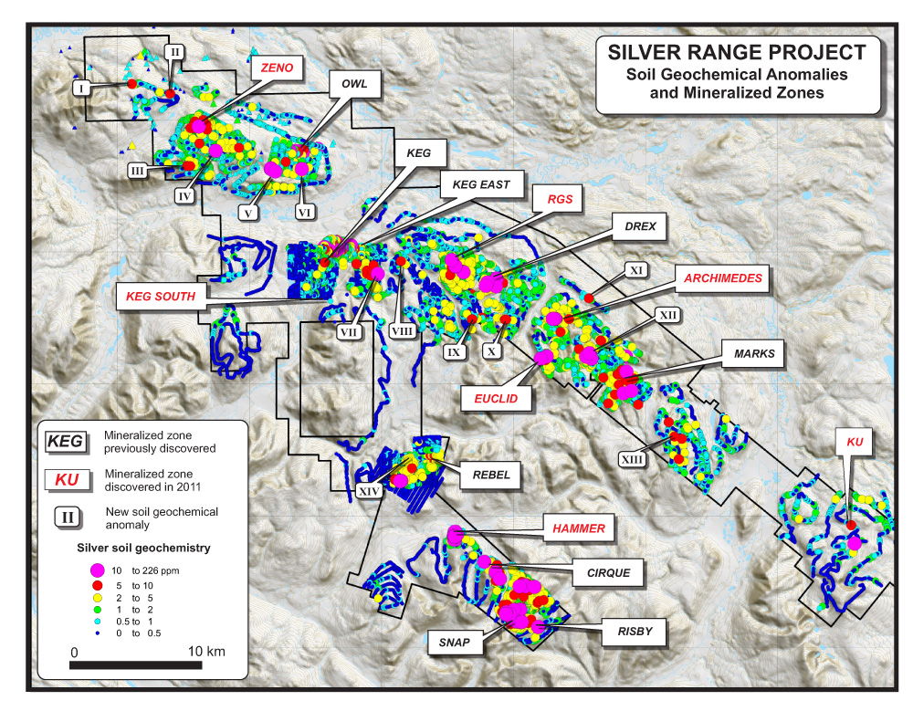
Figure 1